portfolio website templates

3D IMAGERY

Powerful Data From Aerial Images

Our Aerial Photography allows for advanced 2D and 3D images that can be used for sophisticated area, volume and distance measurements. These offer construction projects new tools that do the job faster and with a higher degree of safety.

  1. DATA DEMAND - Your unique requirements define our customized solution. Each location and situation is different so our approach is to gather the facts before the flight.
  2. DATA AQCUISITION - Our pilot fly's the drone capturing a huge amount of data, overlapping pictures are taken from the defined area.
  3. DATA PROCESSING - The data is then processed using the latest in cloud computing. Hundreds of pictures are stitched together to create a high definition orthomosaic map.
  4. DATA ANALYSIS - The map can then be used to perform calculations to dramatically improve your ability to make decisions on the work site.

Scenario

A construction site manager needed to know where his order of gravel was delivered and was the whole order delivered?

Mobirise

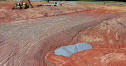
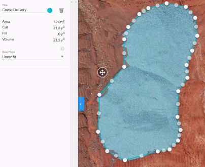
Satellite Images are seldom updated, so using a professional drone company such as ours, afforded a fast way of viewing the work site. This allowed for a quick but high definition 2D image of the area. The delivered gravel could be seen in the bottom right corner of the image.

3D Imagery allowed the construction manager to see that the gravel delivery was not located where ordered and needed to be moved. How many cubic yards did he get?

Mobirise
Mobirise

Area and Volume Measurement from the drone showed that the delivery was less than ordered as he had suspected. He could now calculate the time to remove, relocate and invoice the gravel company for their delivery while having solid proof with sophisticated data acquisition.

  • FAST DATA ACQUISITION - The data mapping mission could be flown in the matter of minutes and the package of information ready and downloadable by the work site manager the next morning.
  • RELIABLE RESULTS - Utilizing volumetrics, 3D digital elevation, surface and terrain models are used to analyze and produce the data sets that are needed for your job.

© Copyright 2019 Northern Lights Skye LLC - All Rights Reserved